- Description
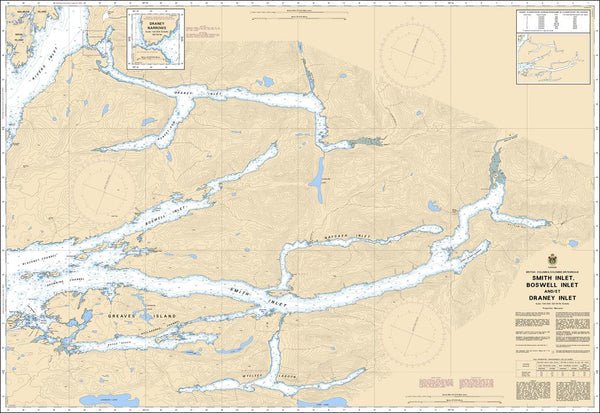
Chart 3931 - Smith Inlet, Boswell Inlet and/et Draney Inlet
*Charts are usually shipped folded, if rolled extra freight charges will apply.
KEY INFORMATION:
CHS Chart 3931 is an official Canadian Hydrographic Service nautical chart covering Smith Inlet, Boswell Inlet, and Draney Inlet on the Pacific Coast of British Columbia. It is a specialized, large-scale navigational tool designed for navigating the deep-water fjord systems north of Queen Charlotte Sound.
Chart Number: 3931
Region: Pacific Coast, BC
Scale: 1:40,000
Edition Date: 1992-02-21
- Draney Narrows: Provides high-resolution mapping for the high-velocity currents, which is crucial for timing safe passage.
- Fjord System Detail: Covers the full extent of Smith and Boswell Inlets, detailing steep-walled shorelines and submerged hazards.
- Anchorage & Soundings: Shows precise water depths and the nature of the sea bottom (mud, rock, sand) for secure anchoring in areas like Takush Harbour or Wycliffe Inlet.
- Navigation Hazards: Clearly marks reefs, kelp forests, and navigational aids for safety