- Description
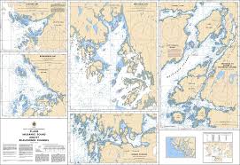
Chart 3910 - Plans - Milbanke Sound and/et Beauchemin Channel
(Before 3723 - Now Replaced by 3910)
*Charts are usually shipped folded, if rolled extra freight charges will apply.
KEY INFORMATION:
- Area Coverage: Focuses on Milbanke Sound and Beauchemin Channel, with detailed insets for St. John Harbour, Higgins Passage, and sections of Beauchemin Channel.
- Scale: 1:20,000.
- Purpose: Provides precise, high-resolution data for navigating narrow, tide-swept channels, identifying hazards, and selecting anchorages
- Hazard Identification: Clearly marks drying reefs, kelp forests, and shallow areas.
- Anchorage Information: Includes detailed seafloor intelligence (depths, sand/mud/rock bottom types).
-
Navigational Aids: Explicitly marks navigational aids for commercial, fishing, and recreational vessels.