- Description
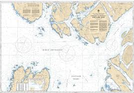
Chart 3960 - Approaches to/Approches à Portland Inlet
*Charts are usually shipped folded, if rolled extra freight charges will apply.
KEY INFORMATION:
- Area Covered: The waters approaching Portland Inlet, including parts of Portland Canal, Alice Arm, Nass Bay, and surrounding features like Butze Rapids.
- Scale: 1:40,000, providing detailed information for coastal navigation.
- Purpose: To guide commercial, fishing, and recreational vessels safely, showing depths, bottom types, coastlines, and navigation aids.