- Description
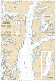
Chart 3936 - Fitz Hugh Sound to Lama Passage
*Charts are usually shipped folded, if rolled extra freight charges will apply.
KEY INFORMATION:
- Description: A high-resolution paper chart covering the Inside Passage on the British Columbia Central Coast.
- Purpose: Navigational chart used by BC Ferries, commercial shipping, and recreational cruisers for navigating the area between Hakai Luxvbalis Conservatory and Milbanke Sound.
-
Details:
- Region: Pacific Coast (Canada).
- Scale: 1:40,000.
-
Features: Detailed bathymetry for Fitz Hugh Sound, Lama Passage, and the eastern approaches to Bella Bella and McLoughlin Bay.