- Description
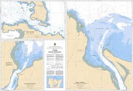
Chart 3895 - Plans - Dixon Entrance
*Charts are usually shipped folded, if rolled extra freight charges will apply.
KEY INFORMATION:
- Title: Plans of Dixon Entrance (Pacific Coast)
- Publisher: Canadian Hydrographic Service (CHS)
- Scale: 1:20,000
- Type: Multi-plan nautical chart
- Coverage: Detailed, high-resolution, close-up, and localized views of specific areas within the Dixon Entrance, designed for safe entry into bays and inlets.
- Key Included Areas (Plans): Brundige Inlet, Aliford Bay, and the approaches to Port Clements.
-
Purpose: Used for navigating narrow, complex passages and identifying submerged hazards that are usually not detailed on broader coastal maps.