- Description
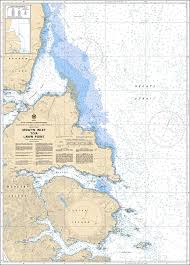
Chart 3894 - Selwyn Inlet to Lawn Point
*Charts are usually shipped folded, if rolled extra freight charges will apply.
KEY INFORMATION:
- Region: Pacific Coast (Canada).
- Coverage Area: The chart covers the eastern shore of Moresby Island, specifically from Lawn Point to Selwyn Inlet, including Laskeek Bay, Cumshewa Head, and the approaches to Selwyn Inlet.
- Purpose: Designed for safe navigation, it is used by mariners, researchers, and wildlife tour operators exploring the area, including the northern boundaries of Gwaii Haanas.
- Scale: 1:73,026.
-
Data Included: Detailed bathymetry (water depths), coastal features, navigational aids (buoys), and hazardous areas.