- Description
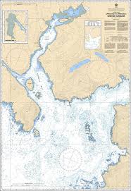
Chart 3686 - Approaches to/Approches à Winter Harbour
*Charts are usually shipped folded, if rolled extra freight charges will apply.
KEY INFORMATION:
- Coverage & Scale: Focuses on the Approaches to Winter Harbour and Forward Inlet on the northwest coast of Vancouver Island at a 1:15,000 scale.
- Navigational Detail: Provides crucial, high-resolution bathymetry for rounding Kains Island, accessing Forward Inlet and Winter Harbour, and identifying safe anchorages near Browning Provincial Park.
- Purpose: Essential for navigating this rugged, high-energy environment
-
Identifiers: Chart 3686, Pacific Coast region.