- Description
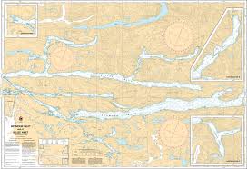
Chart 3552 - Seymour Inlet and/et Belize Inlet
*Charts are usually shipped folded, if rolled extra freight charges will apply.
KEY INFORMATION:
- Description: Covers the intricate Seymour and Belize Inlet systems, known for extreme depths (over 1000–2000 ft) and steep, rocky terrain.
- Scale: 1:50,000.
- Coverage Area: Includes Alison Sound, Nugent Sound, and Frederick Sound, extending inward from the Nakwakto Rapids.
- Identifies rare, safe anchorage spots and drying mudflats.
- Marks depths, submerged rocks, and coastal features for navigation in a, remote, high-terrain area.
-
Often used in conjunction with Chart 3550 (Approaches to Seymour Inlet)