- Description
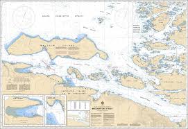
Chart 3546 - Broughton Strait
*Charts are usually shipped folded, if rolled extra freight charges will apply.
KEY INFORMATION:
- Region: Pacific Coast, British Columbia (Broughton Strait, surrounding Malcolm Island, and part of the Broughton Archipelago).
- Scale: 1:40,000.
- Purpose: Essential for commercial shipping (logging vessels), BC Ferries, and recreational boating in the area
- Key Harbours: Detailed mapping for Port McNeill and Alert Bay (Cormorant Island).
- Channels: Comprehensive data for Cormorant Channel, Haddington Passage, and surrounding waters.
- Hazard Identification: Clearly marks submerged hazards, rocky reefs, and aids to navigation.
- Tidal Information: Provides data on strong currents, particularly around Haddington Island.
-
Environmental Areas: Includes information on Rockfish Conservation Areas (e.g., Weynton Passage)