- Description
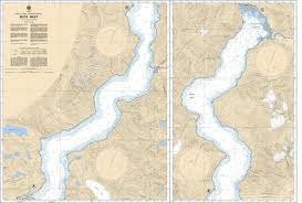
Chart 3542 - Bute Inlet
*Charts are usually shipped folded, if rolled extra freight charges will apply.
KEY INFORMATION:
- Coverage: Covers Bute Inlet from its mouth near Stuart Island to the Homathko Estuary at the northern end.
- Scale: 1 : 40,000.
- Geography: Known for steep terrain (mountains rising over 9,000 feet from the sea), deep water, and significant glacial activity, with detailed coverage of the Homathko and Southgate River estuaries.
- Critical Data: Includes details for navigating Arran Rapids (highly turbulent), and marks underwater hazards and navigational aids.
-
Region: Pacific Coast, BC.