- Description
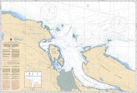
Chart 3458 - Approaches to/Approches à Nanaimo Harbour
*Charts are usually shipped folded, if rolled extra freight charges will apply.
KEY INFORMATION:
- Title: Approaches to/Approches à Nanaimo Harbour
- Region: Pacific Coast, Canada (Strait of Georgia / Nanaimo)
- Purpose: Navigational safety for approaching the harbor, featuring detailed, high-resolution bathymetry for maneuvering in narrow or shoal-infested waters.
- Scale: 1:20,000 or 1:80,000 (Note: Sources indicate 1:20,000 as the detailed approach scale, while others list 1:80,000 for the broader region).
-
Data Content: Includes soundings (in meters/fathoms), shorelines, buoys, lighthouses, navigational hazards (rocks, wrecks), and anchorage details.