- Description
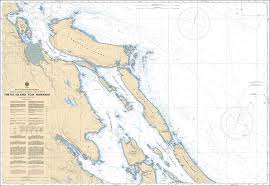
Chart 3443 - Thetis Island to Nanaimo
*Charts are usually shipped folded, if rolled extra freight charges will apply.
KEY INFORMATION:
- Name/Title: Thetis Island to Nanaimo (Chart 3443).
- Region: Pacific Coast, Vancouver Island East (British Columbia, Canada).
- Scale: 1:40,000.
- Coverage: Includes Gabriola Passage, a known Rockfish Conservation Area (RCA)
- Navigation: Used by mariners for safe navigation, specifically around Gabriola Passage and through the Gulf Islands.
-
Compliance: Meets standard Canadian Hydrographic Service (CHS) requirements.