- Description
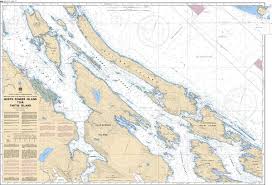
Chart 3442 - North Pender Island to Thetis Island
(Before 3442A - Now Replaced by 3442)
*Charts are usually shipped folded, if rolled extra freight charges will apply.
KEY INFORMATION:
- Chart Name: North Pender Island to Thetis Island
- Chart Number: 3442
- Region: Pacific Coast (Canada)
- Scale: 1:40,000
- Major Locations: North Pender Island, Thetis Island, Salt Spring Island, and surrounding channels.
- Navigational Data: Includes bathymetric data (depths), coastline details, buoys, lights, anchorage areas, and navigational hazards.
-
Chart Type: It is a medium-scale coastal chart designed for safe passage through narrow channels and island-studded waters.