- Description
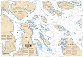
Chart 3441 - Haro Strait, Boundary Pass and/et Satellite Channel
(Before 3441A - Now Replaced by 3441)
*Charts are usually shipped folded, if rolled extra freight charges will apply.
KEY INFORMATION:
- Coverage Area: Includes Haro Strait, the international boundary of Boundary Pass, and the protected waters of Satellite Channel, extending to the approaches of Sidney, BC, and Portland Island.
- Scale: 1:40,000
- Navigational Hazards: Clearly marks shoals, submerged rocks, and other hazards.
- Aids to Navigation: Includes buoys, lights, and navigational markers.
- Tidal and Current Data: Provides essential data for navigating the strong currents and eddies near Turn Point and Moresby Island.
- Environmental Data: Identifies critical habitats within the Gulf Islands National Park Reserve.
-
Shipping Lanes: Details the major, deep-sea channels used by tankers and cargo ships