- Description
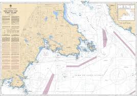
Chart 3440 - Race Rocks to D'Arcy Island
(Before 3440A - Now Replaced by 3440)
*Charts are usually shipped folded, if rolled extra freight charges will apply.
KEY INFORMATION:
- Coverage Area: Southern Vancouver Island, spanning from Race Rocks to D'Arcy Island, including the southern approaches to Victoria Harbour, Trial Islands, and Discovery Island.
- Purpose: Used for navigation by commercial shipping, naval operations, and recreational boating in the Salish Sea/Haro Strait.
-
Key Details:
- Scale: 1:40,000.
- Features: Detailed bathymetry (depths), navigational aids (buoys, lighthouses, beacons), and hazards (submerged rocks, shoals)
- Hazards/Notes: Explicitly highlights the Race Rocks Ecological Reserve