- Description
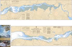
Chart 3058 - Arrowhead to Revelstoke
*Charts are usually shipped folded, if rolled extra freight charges will apply.
KEY INFORMATION:
- Region: Pacific Coast (Inland/Columbia River System).
- Coverage: Arrowhead to Revelstoke (covers the transition from Upper Arrow Lake into the Columbia River).
- Scale: 1:20,000, providing granular detail.
- High-Resolution Precision: Designed to manage the transition from deep lake to narrow, shallow river channels.
- Hazard Identification: Explicitly marks submerged obstacles, rocky shoals, and shifting silt deposits.
- River Transit Data: Provides crucial bathymetry (depth) for the river approach to Revelstoke.
- Visual Pilotage: Includes accurate coastal configurations and landmarks for navigation in a deep mountain valley.
-
Safe Navigation: Used by local commercial operators, anglers, and recreational boaters