- Description
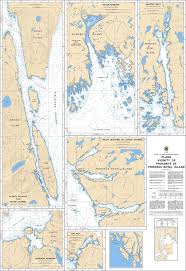
Chart 3911 - Plans Vicinity of/Proximité de Princess Royal Island
(Before 3711, 3723, 3719 - Now Replaced by 3911)
*Charts are usually shipped folded, if rolled extra freight charges will apply.
KEY INFORMATION:
- Region: Pacific Coast, Canada.
- Coverage: Detailed, multi-plan views around Princess Royal Island.
- Purpose: Ideal for navigation in,, and, and, , shoal-infested, , and, , tight, , channels, and, , fjords
-
Navigation: While often used for recreational boating, these charts are suitable for, , navigating, , complex, , areas,.
Commonly Included Areas - Barnard Harbour.
-
Various, , inlets, , and, , channels, , adjacent to Princess Royal Island